Two Successful Seasons for Horizon 2020 HYPERNETS Project at PEA
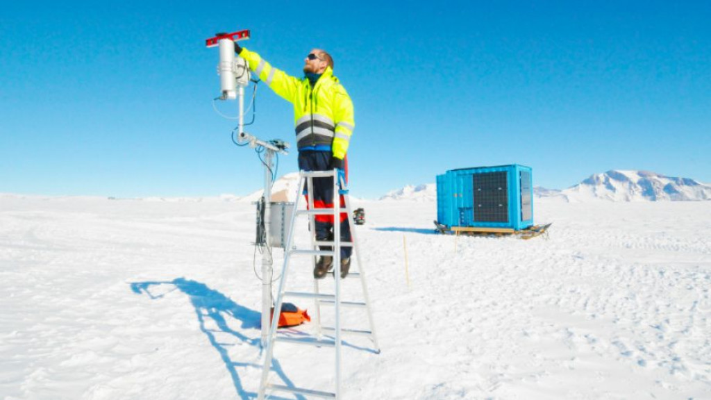
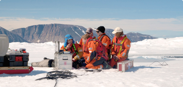
During the 2021-22 and 2022-23 austral summer research seasons, Quinten Vanhellemont from the Royal Belgian Institute of Natural Sciences spent several weeks at the Princess Elisabeth Antarctica installing and maintaining instruments for the Horizon 2020 Hypernets project, which is measuring surface radiation reflectance at different points of the globe, including Antarctica.
In this interview Quinten describes the objectives of the project and what they were able to accomplish over two seasons at the world’s first zero-emission polar research station.
In a few words, could you tell us what the objective of the HYPERNETS project is about?
Space agencies have been launching many optical remote sensing satellites like Landsat, Sentinel-2, and Sentinel-3. Commercial operators are also launching satellites. For example, Airbus and Maxar operate Pléiades and Worldview. These are all optical imaging satellites taking pictures of the Earth.
But there were no or only a very few in-situ stations where measurements were being made to validate, i.e. check the quality of, the satellite measurements. For this reason, the HYPERNETS project developed a new radiometer - an instrument that measures incoming light and light being reflected from a surface - to derive the reflectance of the surface, which is one parameter these optical satellites measure. The project also set up a network of satellite validation sites operating this equipment.
The project has developed a new radiometer capable of measuring land and water reflectances for the validation of any optical satellite mission. This instrument is the HYPSTAR® radiometer that was deployed at the Princess Elisabeth Antarctica (PEA) research station this season and last season.
You chose certain locations around the world to take in-situ measurements to validate satellite measurements. Was this based on where the project partners were located, or for other specific reasons?
A lot of it was based on where the project partners are located, but also to have a wide range of different surface types. We were planning to have about 20 sites ranging from coastal waters, inland waters, forests, deserts, and also the Princess Elisabeth Antarctica. For example, we’ve deployed instruments in the Namibian desert, on the coasts of Belgium, France, and Italy, and in forests in England and Estonia.
Is there any particular reason why you chose the location you did close to the Princess Elisabeth Antarctica? Was there anything special about that particular location?
Satellite measurements of Antarctica (and other snowy/icy regions) are used to understand the earth’s changing environment, so we need a validation site there to check the quality of that satellite data.
I chose the precise location where we put the HYPSTAR instrument as it’s not too close to the station, which allowed us to have homogeneous pixels up to Sentinel-3 resolution. Sentinel-3 has 300 metre pixels. To have a clean pixel, you want to be a couple of pixels away from the station and all the containers and vehicles surrounding it. That's why we put it about 1.8 kilometres away from the station in an area that is only snow, no rock.
The benefits of conducting research at PEA are also based on the availability of light. With 24 hours of daylight during the austral summer, we can characterise the directional response of the snow surface as well. So we don't only measure during the satellite overpasses, but we can measure during the whole day. This allows us to see the reflectivity of the surface change due to changing sun position.
There's also the small scale features on the surface that impact the reflectance, in particular the sastrugi on the surface of the snow that cast shadows depending on the sun position.
Since the HYPSTAR radiometer is sitting on snow, does it need to be constantly maintained?
Last year (2021-22) the instrument was deployed for a few weeks in January-February. This most recent season (2022-23) I traveled earlier to the station (December) in the hopes that the instrument could be deployed for a bit longer. At the end of the most recent season, the HYPSTAR was taken down and packed up days before the BELARE team left on February 16th.
So the instrument has only been there for a few weeks each season?
Yes. Since it’s an optical instrument, it needs light to take measurements. So we don't really need it to over-winter there. Also, that same instrument, now that it’s back in Belgium, will be deployed in other locations in Belgium.
Which partners developed the HYPSTAR radiometer
The main developer for the radiometer was Tartu Observatory. The control box was developed by the Laboratoire Océanographique de Villefranche (Sorbonne University).
Will the instrument be going to the Princess Elisabeth Antarctica for several more seasons?
That’s the plan! Ideally we could make the installation a bit more straightforward, and perhaps ask staff from the International Polar Foundation to set up the instrument. However, at the moment, it's not something that you can attach, switch it on, and start collecting data. But this is something that we hope to improve.
The HYPERNETS project officially ends in April. But we learned a lot during the two seasons the HYPSTAR radiometer was deployed at PEA.
Have you been able to validate measurements from certain optical satellites?
Yes. Last year, I looked at the Sentinel-2 and Sentinel-3 imagery and a colleague of ours at the National Physics Laboratory (NPL) in the UK used it to validate the calibration of PRISMA and Sentinel-2 top of atmosphere data. For these data, they combine our surface measurements and AERONET data (there's also an AERONET instrument installed on the top of the station) This produces a top of the atmosphere equivalent reflectance product. This is actually what the satellite measures: a combination of the surface and the atmosphere.
These are the first satellites we have looked at, but there is an interest from about 20 different satellites and space agencies to use this kind of validation data.
And what would you consider to be a success for this project since it's ending soon? What kind of results would you like to see?
I think the development of the HYPSTAR radiometer is already a big success of the project. This instrument will enable an evaluation of optical satellite missions from many different surface types. The network of sites we have set up will be continued and will expand internationally. For example, we are discussing with US colleagues to set up validation sites in the USA.
And by deploying the instrument at PEA, we've shown that it's quite robust even in relatively extreme environments. This past season we've also asked ESA to increase the observation density of Sentinel-2. For this season we hope to have many more matchups with Sentinel 2 just because now there's an increased observation density.
This past season, we had a longer deployment period and also twice the amount of Sentinel-2 data. So that should work out to more matchups. And since the station is located at such high latitudes, many of the orbits from different satellites overlap at the station. At lower latitudes, you only get two images for every orbit cycle per satellite. But if you move to 72 degrees south, you get maybe three or four images for every orbit cycle. So, you have an advantage taking measurements in the high latitudes: additional data from the polar orbiting satellites.
Also, HYPSTAR will be entering commercial production after the project ends. The goal of this project has been to create a commercially available radiometer. But also we want to keep using them ourselves for satellite validation purposes.
To what extent did IPF engineers assist with the setup of the HYPSTAR radiometer?
They’ve been a big help! During the 2021-22 season, we installed the central pole on which the instrument is mounted. So now it's quite easy to go back and mount the instrument on the pole that's already there. IPF engineers made a mobile solar power container for power in the field.
We know about optical instruments and scientific measurements, the IPF engineers know how to make things work in such a difficult environment!
So the HYPSTAR radiometer is run entirely by solar power?
Yes. I don't think that we ever had any power issues. The mobile power unit is quite robust. It produces more power than the instrument needs.
Download